
New model data suggests an extremely dangerous medicane Ianos will strike into Greece on Friday
Model guidance is now calling medicane Ianos could become one of the strongest Mediterranean tropical-like cyclones on record. The minimum central pressure is expected to drop to near 980 mbar, with sustained winds reaching hurricane-force Category 1 strength. Peak gusts could exceed 200 km/h, therefore, a severe impact is likely for western Greece tonight through Friday morning. Huge amounts of rainfall will lead to dangerous flash floods.
Key messages
Medicane Ianos is the first event of the 2020/21 Mediterranean medicane season. It was officially named by the National Observatory of Athens (NOA). The system formed in the southern Ionian Sea on Sept 16th.
Ianos is deepening and strengthening today, gradually turning towards Greece. A severe landfall with destructive winds and flooding is expected tomorrow – Friday, Sept 18th. Medicane will begin its approach to the Ionian Islands late this evening, likely bringing the worst, most intense winds to Kefalonia and Zakynthos islands.
Along with severe destructive winds, Ianos is expected to bring torrential and excessive rainfall across parts of Greece, resulting in dangerous flash floods. Locally up to around 400 mm of rainfall is likely until Friday evening (36-hour period).
Outer bands of convective storms could produce tornadoes along the coast tonight, due to strongly enhanced low-level shear and instability.
Please read a special forecast discussion – Severe Weather Outlook for Medicane Ianos.
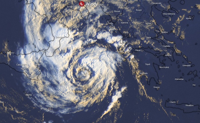
Satellite analysis
The estimated minimum central pressure of Ianos was around 990 mbar on Thursday morning. With the maximum sustained winds of around 50-55 knots (90-100 km/h), and increasing.

Satellite imagery indicates that clouds have wrapped into all quadrants of the system, Ianos now has a well-defined almost symmetrical appearance. The overall weakening deep-layer shear allows further development.

Ianos will intensity into a Category 1 hurricane equivalent system, which should maintain until the landfall on Friday morning.

It appears likely that additional strengthening of the cyclone and convective activity will lead to the development of an inner core. Violent, hurricane-force winds are forecast to develop.
Here is an impressive visible satellite animation of Ianos through the afternoon hours yesterday, Wednesday, Sept 16th. Notice a remarkable formation of the cyclonic cloud bands with the tightening core.